Showing posts with label Schuylkill. Show all posts

Friday, June 17, 2011

A “Quick” Ride to Norristown


This past Tuesday I was in the mood to bike. I felt stressed about my ongoing job search and it was a perfect, partly-sunny 70-degree day. So instead of think of a good route and taking my camera with me I decided to grab my iPod and Loretta and bike up the Schuylkill River Trail.  I put on Lady Gaga’s new album Born this Way and before I knew it I was in Norristown!


Miles
Minutes
Speed
Calories Burned
37.6
157
14.4
1,890


Because I didn’t take any pictures I have no real memory of what was happening on my ride – I also wasn’t paying much attention to my surroundings.  However there are some big landmarks that a cyclist (or anyone I suppose) passes along the way and I’d be remised not to describe some of them.  At some point in the future I will take a camera and photo-document the ride. 

As all can suspect the ride begins in Fairmount Park and goes along the Ridge Avenue detour to Main Street Manayunk, no need to describe or discuss that.  Through the next part one can choose either the Manayunk Canal Towpath or Main Street to Umbria Street. I took both (the streets on the way to Norristown the towpath on the way back to Philly) – the former is all on streets but there are some pretty ridiculous hills and the latter is all made up of boardwalk and gravel, which Loretta doesn’t appreciate.  Both places lead you to Nixon Street, way up in Roxborough, and the beginning of the Schuylkill Trail that leads to Collegeville/Phoenixville and beyond.

The path runs mostly along an old rail line. Sometimes it’s very evident, like right at the beginning near Nixon Street, there are over head wires and the path is enclosed by gigantic trees or rock formations on either side.  On the way to Conshohocken, the only notable thing that I can remember is the area around the Minquon regional rail stop. You cannot see it from the path but there is some nondescript building off the path.  There are always people smoking outside of the stairway too – it makes no sense.  Once in Conshohocken the path then crosses several streets, and crosses old railroad tracks that are gone but apparently it was too difficult to remove them from the path. Or someone thought that was a great design choice; Loretta’s tires would beg to differ. On the other side of Conshohocken is a GIANT steel mill and unlike the other steel mills in the rust belt it’s actually in operation. I find that fact kinda amazing. After the mill there are a few industrial sights peeking out, the PA turnpike and a road to a sewage treatment plant that smells horrendous.  Also near the treatment plant is an odd curly-cue ramp that takes cyclist over top of the rail lines that are in use. It was here where I have never seen some many groundhogs. There was a groundhog that ran along with me for a bit and there were two groundhogs that were about the f…ight.  It was definitely fight, but I wasn’t sure for a bit. Bold move either way.  From the curly-cue and fighting ground hogs Norristown is just about a mile away, up a gradual hill that overlooks the city.  I stopped at the Norristown Transportation Center which is the hub for many suburban bus lines, the Norristown Line formerly the R6, and the Norristown High Speed Line.  The center itself looks like a half-assed, 1980s version of a Mies van der Rohe house, but it does have cold water and that I was thankful for. Again I’ll photo document this ride and research it at some other point, I was just happy to go on such a long ride, it’s the longest I’ve done this year.  

Monday, April 18, 2011

Week 6 in Review (April 11-17)


Even though it was really nice this past week, I only had a few miscellaneous rides.  I think that I’m still thinking of last year when I was working and bike commuting I biked 10 -15 times a week and therefore am disappointed when I only have 1-3.  However one of the rides this week was a trip along the Schuylkill.  A nice ride to the Falls Bridge and back, except that the day I went it was beautiful and there were SOOO many people on the trail, so many that I watched a biker hit and unsuspecting and over-dramatic pedestrian.  Therefore, I decided I’d rather chance it with cars and cycle back via University City.  

Routes
Miles
Minutes
Speed
Calories Burned
2
15.1
65
14.0
758

I’ve now biked through 9.48% of Philadelphia!  Insane. 


I’m still working on a separate neighborhood section so I haven’t calculated any updates for that. Coming soon, hopefully. 

Monday, April 4, 2011

Sunny Fairmount Park Sunday!


I’ve been itching to bike more and more but the weather has not been accommodating.  Today ended up being a beautiful day for a ride; sunny, warmish and a Sunday.  I debated with myself for way to long on where I should go (it was between Fairmount Park and the Delaware) and finally decided on taking a leisurely ride through the park. I ended up going a few more miles than expected.  The stats, link and map are below.


Miles
Minutes
Speed
Calories Burned
14.7
77
11.3
927


Although the Schuylkill trail is a wonderful and gleaming case study in waterfront recreation and revitalization, on a warm early spring weekend it’s a bit TOO wonderful.  My disdain for braking for people with their dogs or runners that are oblivious to their surroundings and uturn in front of you leads me to choose routes that bypass the entire area south of the boathouses.  Additionally, the Kelly Drive trail is usually clogged up with high school, college and professional regattas (today was a high school regatta). While rowers tend to be great eye candy, they and their fans are too numerous for any decent bike ride. This is all leading up to the fact that I started my ride by biking up 22nd Street into the Fairmount neighborhood.  Fairmount is one of the quintessential Philly neighborhoods, except that it’s really hard to get to on foot or transit.  The houses are very well maintained, they have a pretty vibrant commercial corridor (that contains a lot of bars that I’m not too familiar with so I’m not going to vouch for them) and lots of flowering trees. 


Biking north I turned left onto Parrish St and then veered onto Pennsylvania Ave. (the wrong way…shh) to an informal bike crossing of whatever railroad runs through there.  The crossing puts you onto Popular Drive, the east edge of the park, and then turns into 33rd St. as you cross Girard.  There is quite a hill that takes you to the formally named East Fairmount Park as well as the neighborhood, Strawberry Mansion. Before entering the park I biked past a new, and enthusiastic, vegan restaurant.  It seemed a little out of place but via internet research it’s a real place, if you want vegan delivery as far south as Penn hit them up. Vegan restaurants are generally not that noteworthy, but in Strawberry Mansion they are.  The neighborhood is a classic case of wealthy, white neighborhood that was abandoned in the 1950s for the suburbs and became a poor, black neighborhood. Along the southern edge, primarily the area known as Brewerytown, there’s been gentrification by artists and young professionals (hence the vegan restaurant) but as a whole the neighborhood has a lot of large, ornate buildings that have been neglected for decades. 

                                                       
As I entered the park I realized something was happening as there were many parking attendants and a lot of signs for $12 parking. It turned out to be the regattas down the hill but it made for a really awkward confrontation with one such attendant that stopped me to ask me what I was doing.  I answered, biking and starred at her.  Anyway I toured around the drives of a few of the mansions that are settled in the park. A brief introduction to the park, it is approx. 4,100 acres and was formed in the 1850-60s as a collection of private estates and undeveloped land to prevent pollution of the city’s water supply.  One of the “estates” I visited was Mt. Pleasant.  Mt. Pleasant is a Georgian manor that was built in the 1760s by some guy named McPherson.  However, fun fact, it was owned briefly by Benedict Arnold until he became a traitor and they were forced to give up their country house.  Another nearby estate I visited was the Rockland Mansion, now home to PCOP.  I spent a good 5 mins riding around trying to figure out what that meant, Psychoanalytic Center of Philadelphia.  I got nowhere close to that. The mansion however was constructed in 1801 and is a great example of Federal style. 


After that I followed the roads around the reservoir located directly in the center of the park past some interesting park activities. Most people were doing “normal” things, i.e. flying kites, playing softball/baseball, etc.  However there was a group of guys that were all dressed in the same thing with back packs all huddled around each other and moving down the road looking like a bunch of lemmings searching for a cliff.  Upon closer inspections they seemed to be boy scouts that had a hold of some really large tree trunk and just moving it down the road.  There were like 40 of them it was a little strange.  Even though I wanted to I didn’t take a picture b/c I felt that would be stranger. 

Continuing my tour of the eastern portion of the park I biked past his old crumbling building that looked like it once used to be a concession stand.  It actually turns out to be one of the few structures left of the Strawberry Mansion Music Pavilion, designed by famed Philadelphia architect Horace Trumbauer in the early 20th century.  It is a reminder of just how wealthy the area around East Fairmount Park was.  The structure now is crumbling and fascinating. Apparently as recently as 2004 there were plans to renovate the structure as part of a larger bird sanctuary/educational center to be constructed and managed by the national Audubon Society. 


After crossing the Schuylkill River along the Strawberry Mansion Bridge I biked along Greenland Dr. and up what seemingly is the biggest hill in Philly.  It’s not, but to give you context I live (as most of Center City is) around 10 – 30 feet above sea level.  When one is along Chamonix Ave, one is at approx. 260 feet.  Point being there are lots of hills in the park.  However, once you are that high you have the ability to bike DOWN the Belmont Plateau.  This plateau is where the Belmont Mansion sits and, possibly more importantly, has some of the grandest views of Philadelphia in the city.  The view is basically looking over the Art Museum at all of Center City and West Philadelphia. After snapping a few pictures, I biked down the hill and reached the fastest speed I’ve even gotten on a bike, 30mph. 


On the other side of Montgomery Ave. from the plateau is the Fairmount Horticultural Center.  It’s a 20 acres site that was formed for the Centennial Exhibition, the centers building was built in 1976 for the Bicentennial. Many of the trees and landscaping however date back to when the grounds were part of the Centennial.  I have never spent much time on the grounds; I’ve just biked through or have been cockblocked by the fence that seems to have irregular hours. I was hoping for some flowering trees but I think I was in between their blooms.  In addition to the gardens and the greenhouse the center contains a Japanese tea house and gardens.  The building is a replica of a 17th century scholar house.  I think for $5, you can go in and visit it. 


The end of my Fairmount Park excursion was marked by Memorial Hall, the main hall for the Centennial Exhibition and now the Please Touch Museum, and biking around the relatively newly minted running/biking trails nearby.


After that I headed home through some relatively rough neighborhoods in West Philly, where one person decided to point out I was a cracker.  I should have told him that was really cheesy of him to say…ah, ha, ha, but in retrospect biking away is the best thing to do in that situation.  

Wednesday, March 16, 2011

A harrowing tour of Southwest Philly


Yesterday was an awesome day for a bike ride, so after a quasi interview I had in Haverford I met up with my friend Zack who recently moved to West Philly. We decided to bike on a tour of Southwest Philly.  We were debating whether or not to bike around the airport but since it was only in the low 50s, going to cloudy later and still windy we opted for another route.  We ended up riding around for almost two hours!  The route is below along with the stats:


Miles
Minutes
Speed
Calories Burned
21.4
117
11.0
1,397


Zack and I ended up at such southwest Philly sites such as Bartram’s Gardens, the Heinz Wildlife Refuge and Mt. Moriah Cemetery.  Much like my ride a week ago, there is a lot to digest and I took probably too many pictures.  Zack can confirm this as I stopped several times without warning.  I’m only blogging about half of the ride today.  Below is the route that I’m blogging about. 


To begin the ride I biked to Zack’s new West Philly abode, across the ominous and ever windy Grey’s Ferry Bridge; suppose it’s better than a ferry.  After eating some food and hanging out with the cats we started by heading southwest along Springfield Ave and then turned left on 54th headed towards Bartram’s Gardens.  After one of the first of many stressful crossings of trolley tracks and large streets on this ride we ended up in the gardens.

Bartram’s Gardens is a fairly important historical site in Philadelphia.  The gardens are located along the banks of Schuylkill River, one of the few areas south of Center City where a person can go to the river’s edge.  However, the site is also tucked behind the massive Lindbergh Ave, train tracks, and some rough PHA housing, which currently hampers access. 


The site is the oldest living botanical garden in this hemisphere, and was home to John Bartram who was a well-known botanist in his day, his day being the early 18th century.  He collected seeds and plants from all over the world and brought them back to his Schuylkill location.  In the 1720s he designed and built his house and original garden, both of which still stand. 


Zack and I spent some time wandering around the garden trying to find the elusive Ginkgo Biloboa tree.  It’s claimed that it’s the last of three original trees introduced to the US, it dates from 1785.   I was convinced that it blew down in the really large windstorm we had last year and since we never found it I’m going to assume I was right.  Jeremy – 1, History – 0, sadness.  Anyway in our hunt we did find this bush of sticks (see below).  According to the sign it was named after Ben Franklin (shocked face), Franklina, and there are no remaining ones in the wild.  In fact the last one in the wild was seen in 1803 and all Franklinas grown today are direct descendants of the Bartram’s plant


Two other cool parts of Bartram’s Gardens:  they have amazing skyline views and there were signs of spring.


After we left Bartram’s Gardens we began to bike down Elmwood and lo and behold, more trailer sized rowhouses!! Outside of their South Philly habitat.  Maybe, unlike the Franklina, they are multiplying and they are retaking the city habitat. I’m obsessed with these tiny places. They’re so silly looking. 


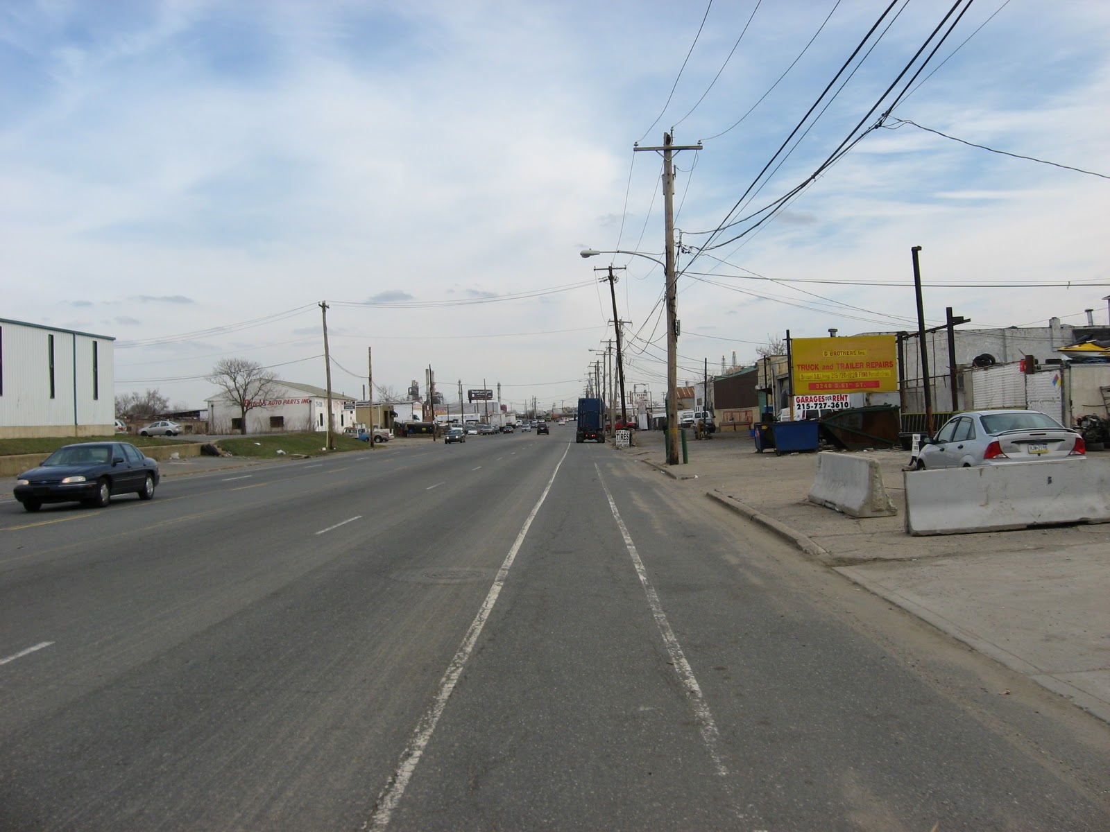
I’ve taken the Lindbergh Ave. route to Heinz before, and as we still weren’t sure if we wanted to go around the airport or not, we took one of the most industrial, auto-centric routes I’ve ever taken; 61st street , left on Passyunk which turns into Essington and then right on Bartram Ave.  These are all roads  that are at least 5 lanes of traffic, most of the time more.  We chose this route because Google told us there were bike lanes on them.  Well, there were, so good job Google, but bike lanes do not equal bike friendly.  Especially when you find the regions auto salvage yards, there were so many car doors, bumpers and tires. 


In amongst all the salvage yards were an astounding number of gentleman’s clubs.  To quote my riding buddy “This area is full of car parts and lady parts” it was true.  We decided that the following had to be the classiest of these establishments. 


As we biked on we lost our bike lane for a bit which was a little nerve racking, and used cars and ladies turned began to turn into new cars and no ladies.   There were so many car dealerships.  Lucky for us Essington Ave had a service lane. While the main part of Essington Ave has been recently paved and has a new bike lane we chose the route with less chance of becoming road kill.  It also gave us an opportunity to find the Simeone Auto Museum.  It’s mysterious, we never did find it.  But the sign sure helps. 


When we turned onto Bartram Ave. we were pleasantly surprised by such a large shoulder.  Until we realized that the cars had to turn right and then there was no shoulder.  As well as on the other side of the intersection, leaving us with a  strip of pavement about 2 feet wide to either not crash into a rather large curb or get creamed.   


However at one of these intersections (Bartram and Island Avenues) we found what seems like a shanty town. There were sheds that were made of corrugated metal and seemed to be stacked as well as a drunk’s house of cards. Even if you look at the Google satellite image it looks like a shanty town, in amongst large office buildings and freeways.  It turns out that after some research the town is actually Eastwick’s Common Ground community garden, which has been a community garden for over 30 years. It’s over 7 acres and 160 lots. Naturally, the article I found about it were about how the airport expansion is threatening to take over the land and they’re lease is up in June. 


That is all for today.  At a later date I’ll blog about the wildlife refuge and the awesome cemetery we found.  

Monday, March 14, 2011

Ride along a flooded Schuylkill


On Friday I started my day off by biking to meet my friend Julie at La Colombe and as it seemed to be getting sunnier I though what a great day for a tour of the Schuylkill River, to visually see what the effects of 1.5 inches of rain has on the park. I had noticed earlier that the river was reaching flood stages in Philadelphia from weather.com. My idea was to bike up the path to the East Falls bridge and then back down the west side of the park. Not much more than 45 mins.

However once I started my ride it began to get cloudier and the wind really picked up.  Anyone that has ever ridden a bike in wind can attest to the fact that it’s a horrible experience.  I’d like to claim that it is worse than walking or even running in the wind, I don’t know about running really, but I think biking is worse.  Especially for me, Loretta has a steel frame and weighs more than 30 pounds.  So I cut my tour short and only biked up to the Girard Ave. bridge and then back home.

There were a lot of people on the trail that seemed to be doing the same thing so there was more dodging of “tourists” then I expected.   The failed experimental wetland right below the Walnut Street Bridge was definitely more wet than land, reaching almost over the shoreline wall. 


As I headed north and as the wind picked up, there was more evidence of flooding; the area between Chestnut and Market was all underwater, the path below the Waterworks restaurant was inundated.   One of the most intriguing areas underwater was in the sculpture garden north of the boathouses and south of Girard Ave.  I have cycled past this spot many times but have never really stopped there until I saw that parts of it were underwater.   It is amazing to think about what this area has had to withstand.  The flooding that I saw was only very minor.  I believe the river was only 6 inches above the flood stage. 


Because of the wind I turned around just north of the Girard Ave. Bridge and headed back home.  All in all the day’s bike totals were as follows:

Miles
Minutes
Speed
Calories Burned
8.49
40
12.7
481


Here is the route:


Wednesday, March 9, 2011

Not all of the Schuylkill is gleaming

In the theme of this blog and my disdain for job hunting I went on an overzealous bike ride today.  I even started the bike ride by washing Loretta, my bike.  Loretta is named such because she is old and the name reminds me of the 1970s, which is when she was made.  So after a wash and some air in her tires we were off to explore the wonderful world of South Philadelphia.  All in all, we biked for a while and since I got my digital camera to work I was more into exploring than I was into biking.  The whole route ended up being the following:


Miles
Minutes
Speed
Calories Burned
17.9
95
11.3
1,144


However, because I took over five dozen picture and visited so many new places I’m not about to blog about it all right now.  So the following bright yellow route is what I’m going to blog about today, you can tell how crazy the bike ride was though:


All but 4 blocks from my house are these elevated train tracks, the 25th St. viaduct I suppose would be a more appropriate name.  However they are not like the El in west or north Philly or even the Reading viaduct north of Chinatown. This is made out of concrete (which always worries me when I’m physically underneath them) and travels the ENTIRE length of 25th St. (approx 1.25 miles).  However in the summer it makes a terrific shadeway and there is barely any traffic on 25th Street.  Additionally the inner lanes (which are faster) are blocked by the ever present concrete columns holding the whole monolith up.  I think it kinda screams bikeway. 


I didn’t bike all the way down the 25th Street viaduct but instead headed west on Reed Street. After circling one of South Philly’s few block parks, Stinger Park, at 33rd and Reed I journeyed under I-76 and over the CSX tracks to check out the progress at the Grey’s Ferry Crescent.  Although I don’t believe it’s technically open until later this month or next, I visited the Schuylkill.  It is almost ready; the area is in dire need of grass.  I’m not sure if they are going for a patchy grass look or what, but there are only patches of straw throughout the site. Judging from the south side of the site the project looks as if it’ll tie in tremendously well with the Schuylkill Banks we all know and love north of Locust.  There are similar rocks and benches to sit on, trees and lighting lining the path. The hard edge has more of an industrial feel to it, similar to Pier 53 on the Delaware.  One of the coolest parts is the large concrete supports that look like they’ve been deteriorating for decades. With the backdrop of the floating bridge in the river, I love it.  


Subsequent to exploring the crescent and the pocket of houses that are along Reed Street I began a venture down Warfield Street.  The street pretty much runs parallel to I-76.  Many people see the industrial landscape on their way to the airport; I got a firsthand look at it.  With a road that seemed barely travelled on I figured it was pretty safe to ride and take pictures.  Additionally, there are some great stretches for seeing how fast one can go on a bike, and you’re not missing much scenery.  In the meantime you have strings of power lines and never-ending rusty chain link fences. 


There is a stretch of road that heads away from the freeway for a bit and you have to make a hard left before running into a gate for an oil storage field.  As soon as a made that left there was a giant semi barreling for the gate and me. No regard for a little biker.  Then came a trickier part, there must have been an exit ramp for industrial wasteland while I was away from the freeway because there were a mob of cars that acted as they were still on the freeway.  Lucky for me the shoulder was very wide and fairly clear of debris.  My new friends were not following the 25mph limit.  I probably wouldn’t either. 


As I sailed around a corner heading to Passyunk Ave., I discovered this pocket of civilization that had to be no more than 40 odd rowhouses, a corner bar, a pint size park and TOWERING empty oil tank. No really the oil tank was in these people’s backyards, I suppose they didn’t have the benefit of zoning when Sunoco or whoever built it.  With the tank aside, it was quite the adorable little microcosm. 


Crossing Passyunk Ave. (much wider when you’re this far south) by running a red light, I biked down the access road leading to Sunoco’s Philadelphia refinery.  After snapping the following picture:


I was stopped by this car and a man rolled down his window yelling at me that I can’t be taking pictures.It wasn't even that good! However, seeing that he was in a car with several grungy men I hightailed it out of there and was greeted by this sign which I found amusing and an appropriate moral to end of my industrial tour: