Showing posts with label Central Delaware. Show all posts

Thursday, August 4, 2011

Over the Ben Franklin Bridge! (Camden Part I)


A few weeks back I took an ambitious ride through New Jersey. It all started when I was flying into PHL and I noticed a distinctly planned neighborhood tucked between two marshy waterways and a park that juts out into the Delaware overlooking South Philadelphia. I immediately thought, “what a cool area to explore, I’ve never really been in New Jersey!”  Well it turns out I know very little about New Jersey.  I rode through Camden’s downtown, their civic and industrial waterfronts as well as some neighborhoods leading into Fairview (the distinctly planned neighborhood eluded to above) and from the there, into Gloucester City, NJ. Over the next few blog posts I’ll depict what I discovered. 


Unfortunately, my camera broke half way through the ride which not only limits this series but future blog posts until I can buy a new one. However, with that sad fact behind me, below are the stats and a map of the ride in its entirety. 


Miles
Minutes
Speed
Calories Burned
18
105
10.3
1,264


For the beginning of this series on the Jersey –side of the Delaware there is no more appropriate landmark to start with but the Ben Franklin Bridge.  It’s also very appropriate as this ride is foreshadowing my month of August. I’ll be crossing the bridge every weekday for the next three weeks in order to instruct, CYLCE camp. This camp is geared toward Camden youth and getting them comfortable with biking through the city and regional greenway network.

However, to the ride at hand; I live a short distance from the beginning of the bridge but as a cyclist it’s one of the most treacherous miles of biking in Center City.  Not only are there cars whizzing by on 5th, 6th and 7th Streets (the only viable options for getting to the bridge), it is damn near impossible for a new cyclist to figure out how to get to the one open walkway. On top of the confusing and fast moving traffic patterns there are “historic” street pavers EVERYWHERE. On 5th Street for a block, on Chestnut Street for a block, and on the SIDEWALK to get to the bridge’s walkway!  There should be a rule that if the street hasn’t had belgian block or cobblestone in the last 75 years then it doesn’t need it now.


The Ben Franklin Bridge is a large and old bridge. It was built between 1922 and 1926 as the first permanent pedestrian/automobile crossing between Philadelphia and New Jersey.  The steel suspension bridge was originally named the Delaware River Bridge and was world’s longest suspension bridge until 3 short years later the Ambassador Bridge opened between Detroit and Canada. The bridge itself is 9,700 feet long (from entrance to entrance) or 1.8 miles. (However, as a bike travels the distance is only 7,800 feet or 1.5 miles). Rising from the city skyline, the bottom of the bridge reaches a height of 135 feet above the Delaware. It’s quite an engineering feat. 

It is also quite a cycling feat.


As the bridge provides 135 feet clearance above the water, the pedestrian/bicycle path is at least 15-20 feet above the car deck at the center. This means that a cyclist reaches a height of 160 feet above the Delaware. After a few rough calculations I found that this means that there is an average grade of 4.1% on the Philadelphia side and 3.4% grade on the Camden side. The reason the grade is much less on the Camden side of the bridge is two-fold: 1) the walkway ends before the bridge does and one has to walk down a set of stairs and 2) the approach is longer on the Jersey side. 

The bridge provides spectacular views of Philly, Camden and the Delaware River as well as some great 1920s architecture.  About 2,000 feet from the Philadelphia entrance there is a plaza (or more like a wider sidewalk) around the bridge’s anchorage (where the suspension cables are anchored).  It offers a detailed view of the bridge’s architecture as well as the ability to step out over the PATCO lines.


A few little known facts about the anchorages are: 1) there is an abandoned trolley terminal under the Philadelphia side; however it was never used as trolleys were becoming passé in the 1920s. 2) There are beautiful lobbies/rooms inside the pedestrian part of the anchorages that contain murals of various transportation modes throughout time. The public rooms were rarely used and are now completely abandoned. 

Below are some of the vistas of Philadelphia from the bridge’s walkway:


From the anchorage plaza there is another 1,700 feet of climb before reaching the apex of the bridge.  From there it’s smooth sailing until the steps on the Camden side. 


Before cruising down the rest of the bridge I stopped at the Camden anchorage to take some pictures of downtown Camden and their waterfront.


This is an appropriate place to stop for the time being. Stay tuned for the rest of the Camden waterfront series.  

Tuesday, July 12, 2011

Week 18 in Review (July 4 - 10)


It’s been hot in Philadelphia and as a result slowed my biking explorations. Between that and trying to find a sustaining income I only got around to biking twice in the entire week.  One ride through Fairmount and Northern Liberties was just out of boredom and the other was with a NEW bike riding buddy, Ben.  I was in Ben’s wedding earlier this summer and as a wedding gist Ben and Sarah got new bikes (not from me, that’d be awfully generous).  On Saturday we decided to bike along the Delaware River, which I had chronicled previously.  We only made it to Northern Liberties before we had a a craving for food. After spending more than an hour at the Green Olive, a healthy/veggie friendly take out market, we finally moved along Delaware and Richmond Avenues.  Traveling past the casino, through Port Richmond and along the big-ass road near the Tioga port we headed away from the river search of a better way home.  FYI: Richmond Avenue might be one of the worst roads for biking. Not only is it fairly broken up, there is approximately 4 feet between parked cars and the route 15 trolley tracks, sometimes less depending on the a driver’s ability to parallel park. I suggested that we head to the Frankford Transportation Center to fill up our water bottles. Much to the chagrin of Ben it was not a couple blocks away as I eluded but a couple miles. However we made it and decided to bike under the El as it would provide shade on our way back.  That turned out to be false as the sun was setting, but we did get to see some of the finer citizens of Philadelphia. Kensington Avenue is hopping for being cockblocked by a giant elevated rail line. As we travelled back through Northern Liberties Ben got a flat tire so we ended up going to A Trophy Bike Garage (which I didn’t realize was connected to Trophy Bikes in University City until I just looked it up) and then got an iced coffee at One Shot Coffee (which possibly might be the cutest coffee shop around, sorry Good Karma).

As always here are the stats for the past few weeks. 


Routes
Miles
Minutes
Speed
Calories Burned
2
28.5
140
12.2
1,661

Make sure you check out the Geographic Analysis page, but some highlights of the changes in my riding are that biking through Frankford, Juniata and Upper Kensington added a lot of new area to my total area.  I’m currently up to 30.5 sq. mi. or 21.1% of the entire city!  Due to Ben and I’s lunch as well as they pit stop at the bike shop, Northern Liberties is the 11th neighborhood I’ve biked through more than 90%. Additionally, I’ve biked through 98% on Center City (from Vine to South) and 92% of “Greater” Center City (From Girard to Washington). I don’t know, I found that fascinating


Tuesday, July 5, 2011

Week 16/17 in Review (June 20 – July 3)


The past few weeks I've been a little busy and have not been able to update Urban Cycle as much as I’d like. I was on a vacation in Maine for about 5 days and then I've been busy trying to piece together some odd jobs to make a little bit of income.  Income is good for me, but unfortunate for Loretta as I do not get to ride as often. However, here is an update for the last half of June.

Aside from the rides for groceries or to go visit people the only rides I have taken in the past few weeks are to do laps around FDR Park in South Philly.  It’s my favorite park to ride around because the loop road has low traffic (except for during a Phillies game) and there are no stops. I can just ride, and ride, and ride until I’m blue in the face if I want to. I went to the park twice in the past two weeks and did a little exploring afterwards. After biking around FDR the first time I ended up traveling to the Gray’s Ferry Crescent to check out the progress. It is still not open but they at least have some grass planted. I’m not really sure what’s taking them so long, it’ll be sad if they open it in October because then it’ll be cold again. Afterwards I biked down a small industrial looking street (I guess it’s an extension of Schuylkill Avenue) which ended up in a really large train yard. It was awesome to see trains rolling by, but I didn’t want to overstay my welcome. People get real fussy when an over-curious cyclist ends up in a vast industrial site. 


After the second trip around FDR Park I biked past the stadium along Pattison Ave. It was during a Phillies game so there were a lot of people to dodge. I saw the beginnings of Philly Live, which is a retail and entertainment hub replacing the Spectrum. Originally proposed in the mid 2000s, the project was tabled due to economic conditions and recently began to move forward but only about a 10th of the original plan. It'll apparently open in 2012 and contain 45,000 square feet of retail/restaurant space. It’s exciting to see something move along that is not additional parking. I continued along Pattison until it turned into a Columbus Blvd, which is a very long, lonesome and truck–filled stretch. After reaching Pier 70 I ducked in along the big box stores to bike along the beginning of the Delaware River multipurpose path constructed a little over a year ago. The path follows the river’s edge and ends near Pier 53 Park which opened April, 2010. The park is an acre of native, waterfront vegetation along decaying piers and a portion of a concrete pad. The area is designed to allow plants to break up the impervious area over time and reclaim it. It’s a pretty awesome area for only costing the Delaware River Waterfront Corporation $570,000; although the wood fence is already starting to show weathering presumably due to a lack of staining. 


As always here are some stats of the past few weeks. 


Routes
Miles
Minutes
Speed
Calories Burned
6
63.4
273
13.9
3,261

These past few weeks I really increased the amount of South Philadelphia that I have reached by bicycle. So much so that Point Breeze and Grays Ferry are two of my most biked through neighborhoods. Impressive because Point Breeze is a little over one square mile.  With these mini-adventures I increased my area and percentage slightly to 29.06 sq miles or 20.26% . Make sure you check out the Geographic Analysis page for all the deets.


Thursday, April 21, 2011

Industrial Philadelphia: Lower North Delaware and Hunting Park East


This post is a continuation of the epic bike ride I took through the northeast. On that ride I biked through two industrial areas: the area that is just north of Fishtown along the Lower Delaware River and Hunting Park East. This conveniently (and nerd-aly) allows me to compare the two areas in a very plannertastic way.  Additionally, while doing research on this ride I came across an amazing Industrial Land Atlas allowing me to really geek out.  The atlas was prepared for the City of Philadelphia by the innovative planning and design firm, Interface Studios. I love these guys; they do some amazing work and have some of the most compelling and well designed infrographics.  Anyway, with this atlas I was able to really understand both areas.  I was inspired to make a map for this post. The following is a map of the two industrial areas and my bike ride for reference.


Lower Delaware Industrial Area


The Lower Delaware Industrial Area area stretches from the under-utilized Delaware Generating Station (near Penn Treaty Park, where I left off last post) to just north of the Betsy Ross Bridge, about 4 miles long.  According to the Industrial Land Atlas the area is approx. 950 acres with a land vacancy rate of 19%, a tad bit higher than the city’s average of 8.1%.  

Part of the reason for such high vacancy is the area contains one of the largest vacant parcels in the city, the former William Cramp and Sons Shipyard.  Dating back to 1825, the yard built the first battleship in the U.S. Navy, the USS Indiana and some of the first major American-built ocean liners.  The yard was sold in the 1920s and closed shortly thereafter, only to be reopened during World War II in order to build destroyers and submarines.  The yard officially closed in 1947 and has practically remained vacant ever since. In 2004, Pinnacle Entertainment proposed building a casino on the site, but the plan was abandoned and SugarHouse was late developed. Today the site has reverted back to natural grassland with a few trees having popped up throughout the decades. Along the edge of the site (where Beach and Richmond streets intersect) the roads are hard to maneuver and completely trash strewn.  However on the sunny day I went there were families traversing the cobblestone street on their way to Penn Treaty Park.  If that doesn’t show latent demand for a greenway I’m not sure what does! 


As I biked further north along Richmond Ave, then eventually along Delaware Ave again, I found areas that were still productive industrial uses, huge uses. Some of the highlights area as follows:

Riverside Material, at the corner of Richmond and Allegheny, a company specializing in asphalt materials. The company occupies only a small portion of a land parcel on which was home to the Reading Company’s terminus for anthracite coal. 


Westway/Kinder Morgan Petroleum terminals, I don’t have much information on the area but I have this awesome picture that shows a bridge of pipes that cross the extremely wide Delaware Ave. 


Tioga Marine Terminal, a 116 acre shipyard that is fairly active.  According to the Industrial Land Atlas a fun fact is that the terminal is home to ships that bring much of the region’s fruit in from Chile. 


A large waste water treatment plant


Lastly the Richmond Generating Station, an abandoned relic similar to the Delaware Generating Station that is used only during peak load periods.  It has been the back drop for two movies filmed in the area:  12 Monkeys and the Decepticons’ lair in Transformers 2.  Unfortunately I have no good pictures of the building.

Further past the intersection of Lewis and Delaware is a bridge over the Frankford Creek which looks like it was built by a local Boy Scout troop. I, of course, had the desire to check it out.  After biking through a puddle, crossing the bridge, and snapping a few photos, I came face to face with TWO semi-trucks attempting to cross the rickety bridge.  It was scurry.


An interesting point in this ride along the Delaware was the discovery of a small park, at the end of Allegheny Ave, named Pulaski Park. Named after a Polish commander in the American Revolution the half acre sliver is owned by the New Kensington CDC and seemingly used primarily for fishing. The park is about as forgotten as the person for whom it’s named.  With geometric mounds and very straight paths that lead to a rather bland plaza, the park looks as if it was designed in the 1970s and hasn’t really been touched since (with the exception of a new-looking railing along the river).  There are no trees in the tree wells, two benches, one of which is busted, and an area of rocks which you could go down onto through a 7 foot chain link fence. Additionally, I was fortunate to be in the presence of a very grumpy fisherman (pictured) and an odd many doing some sort of yoga on the rocks/tires below. 


Hunting Park East

After journeying through several non-industrial neighborhoods I ended up at the corner of Luzerne and I Streets and the edge of the Hunting Park East industrial area. Sidenote: Who knew that Philly had lettered streets? AND they go all the way to O St. in the neighborhood of Juniata. This area is located between the Juniata and Hunting Park neighborhoods of North Philadelphia, just west of the Frankford Creek.  According to my research the area is 821 acres and is privy to a considerably lower land vacancy rate than the Lower Delaware, 10%

One of the fun facts I learned from the Industrial Land Atlas is that the area is home to one of the nation’s largest Coca-Cola bottling plant/distribution center, along G St. between Erie and Luzerne Avenues. The plant produces 30 million bottles of Coke a year and employs 1,200 people. I guess that would have been a serious closure if Coca-Cola went through with their threat if the soda tax was passed, luckily it wasn't. The area has much smaller industrial parcels and therefore many more business scattered among its acreage. Some of the larger manufactures/warehouses are: Conoco Phillips, Case Paper Company and J.B. Hunt Distribution Center.  In addition to the smaller parcels, the lower land vacancy rate and the fact that the area is sandwiched between two dense neighborhoods gives the Hunting Park East industrial area a much more diverse feel than the Lower Delaware.  It’s more vibrant in a way, scattered among the industrial buildings are shopping centers, school and civic buildings attracting much more traffic than found along Delaware Ave.  This provided quite the quandary for me on my bike as people were much less aware of their surroundings as they sailed down Luzerne Ave, but there were many more cars for me to watch. 


One last note, even though the Frankford Creek lies east of the industrial area, it is just as disgusting if not more so than when it enters the Delaware.  In fact, it’s like a mini-L.A. River in this area. 


Wednesday, April 13, 2011

A Spring Tour of the Central Delaware Waterfront

The beginning of this epic ride began with a warm, sunny 74 degrees and so many trees with spring flowers it was like riding an allergy cloud.  Despite the sniffles it was absolutely gorgeous!  I took the ever popular Pine Street bike lane all the way to Front Street, over I-95 to Penn’s Landing. Even the ominous, expansive Columbus Blvd. was decked out in spring colors; attracting birds, bees and even bikers!


Penn’s Landing/the Center City waterfront has some interesting bike infrastructure. First off the place is not very friendly for anyone who is not in four wheel vehicle; it includes a freeway and a six lane “boulevard”. In full disclosure, I have a personal beef with the Penn’s Landing as I think the concrete and asphalt design is the WORST festival space ever, one of the main functions it is billed as. In the summer when the city is 92, Penn’s Landing easily has to be 112, and it’s on the water. Anyway, apart from my personal feelings the area has TWO bike”ways” thorugh it. First, there are the standard 4 foot bike lanes adjacent to the lanes of traffic along Columbus Blvd. Then there is an awkward, yet valiant, attempt of a bike path along the river cutting through Penn’s Landing’s promenades. This path was very recently opened (Early 2010) and is a part of the  Center City District's efforts to reprogram the waterfront and make it more user-friendly.  The trail begins as an off-road, multi-use trail behind Wal-Mart at Pier 70 and continues off-road until Reed Street. Then the path becomes a blundering painted swath along the boulevard’s sidewalk until it ends currently around Race Street.  

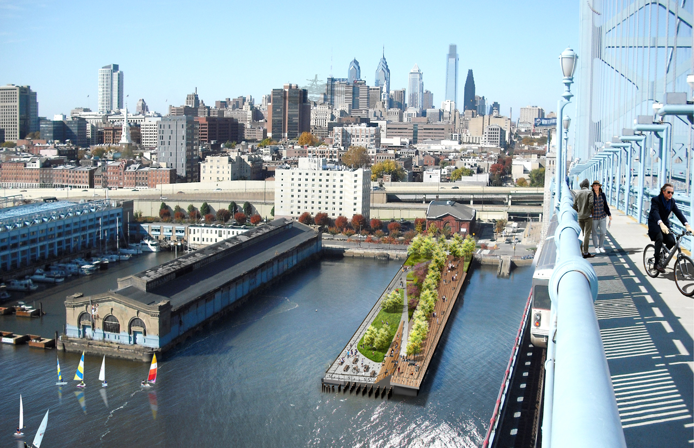
Speaking Race Street, I biked past the new Race Street Pier which is well into final construction stages for its May opening. This project is probably one of the most innovative and hopefully transformative projects along the Central Delaware River. The pier, formally known as Pier 11, was an abandoned finger pier that is best known for as the area where the Duck Boat tours previously launched into the river and being directly next to the Ben Franklin Bridge.


As part of the Civic Vision for the Central Delaware Plan, the Delaware Riverfront Corporation led a design contest for the multi-million dollar project. The final design by the renowned landscape architecture firm Field Operations was chosen in 2010. The pier is on par with the type of design that is found along the High Line in New York City, another one of Field Operations’ project. When finished the space will have essentially two parts, a gradually rising promenade and a passive lawn area. 


Continuing up Columbus Blvd/N. Delaware Ave I abandoned the sidewalk for the bike lane and veered right onto Penn Street, home of the Waterfront Square monstrosity.  Now if there wasn’t enough to dislike about this place: the disregard for scale, the deficit of public waterfront land, the uninspired architecture, there also is a lack of infrastructure upgrade. I’m not really sure how such a huge development got away without repairing the road right outside of of its gates. When attempting to sell condos for $600,000 one would expect that you wouldn’t get a flat when leaving your abode. Maybe they wouldn’t be on the auction block if they repaired the road…nah, that's wishful thinking.


On the other hand Waterfront Square's neighbor, SugarHouse [Casino], has a surprisingly lovely public path along the river; if one can find it through the sea of parking. For those of you unfamiliar with the Philadelphia casino battle, in short, SugarHouse is one of the two casinos that were placed in the city when the state passed gambling legislation in 2004. While the six-year battle to rid the city of casinos has successfully been able to revoke one of the licenses, SugarHouse opened in late 2010 to the chagrin of many city officials and residents. The current building is actually meant to be a temporary structure from my understanding. A more permanent, larger, structure will be constructed when/if there is a market for a hotel and meeting space. For now we are left with a building that is a spruced up Home Depot. 


After biking through the parking lots and then back up to Delaware Ave. I noticed the asphalt pathway that was beckoning. Running along the main entrance to the casino and past a stormwater runoff ditch, the path led to a little urban oasis


 The “path” consists of a wide promenade with benches placed along the northwest side to overlook the river. Along the southeast side of the main promenade is a wavering strip of gravel running down a rocky, fenced-off shoreline. In between the two paths is a landscaped buffer with fairly mature trees and lighting. The whole area has a relatively peaceful air about it despite being next to a casino; it is probably different at night.  There are also some amenities that boggled my mind, like bike racks.


Along the river is an array of industrial ruins, pylons for old dilapidated piers and a cluster of old industrial pipes. While unsuccessfully researching what these pipes are/were used for I came across two interesting facts. First fact, the Jack Frost Sugar Refinery that used to stand on the site was HUGE. It was an 18 building complex (some buildings were 10 stories) and in its heyday employed 1,500 people. Also, there is an annual magazine for casino design. One of those facts is more interesting than the other. However, all I could surmise about the pipes is that they are remnants of bygones past and don’t do much now. 


Jack Frost Sugar Refinery in the 1990s
Credit to: myng_arlong on Flickr
Practically right next to the casino is the only large area of green space one can currently find on the Central Delaware, Penn Treaty Park.  Situated next to an aging power plant and the former site of a massive sugar refinery, this swath of green has actually been a park since the late 19th century.  As the name indicates the park is the supposed spot where William Penn signed a treaty with the Native Americans, in the 1680s. In old paintings Penn is standing under a great Elm tree, well currently there is an obelisk that stands in the same spot. 


The park is roughly seven acres and is managed by the Friends of Penn Treaty Park. It is a fairly passive park with much of its area dedicated to lawn. There are a few picnic tables and a playground next to the obelisk on the north side of the park. Along the river is a rocky shoreline one can step out onto for a spectacular view of the Ben Franklin Bridge and Camden. 


That concludes the tour of the Central Delaware. Next topic is the industrial lands that lie further north beyond the power plant.