Tuesday, May 31, 2011

Week 12 in Review (May 23 - 29)


I got Loretta back from the shop/doctor last Monday and had a momentary panic attack when I began to bike away and my front brake got stuck my chain fell off and I realized Breakaway Bikes failed to reinstall my computer. I went in about to cut someone. However, the guy fixed all of it pretty quickly, albeit rather begrudgingly.  I did have a conversation that went kinda like this:

Me: “Um, also my bike computer is in this bag” 

Bike dude: “oh yea we took it off because it was broken” 

Me: “oh it’s not, it just looks a little beat up”

Bike dude: ::blank stares::

Me: “so, can you put it back on?” 

After all that hassle I didn’t really take advantage of Loretta’s tune up.  Aside from some errand running and hanging out during the middle of the week I didn’t bike anywhere. It was a pretty busy week getting ready for the wedding of Ben and Sarah. (Congratulations, Berah!!)  I did get a few rides in though:


Routes
Miles
Minutes
Speed
Calories Burned
4
14.0
71
11.84
865

I only covered an extra tenth of a square mile, mostly in Queen Village, which is now one of my top 10 neighborhoods.  With this extra boost my total area is 24.64 sq. mi. covering 17.19% of the city.  There was minimal changes to neighborhoods, but go ahead and check out the Geographic Analysis page anyway. 


Monday, May 23, 2011

Week 11 in Review (May 16 - 22)


This week is kinda a flop as far as biking. Loretta went to the doctor for a tune-up, and new handle bar tape (hopefully). While she has been in the shop I flew back home to Ohio for the week mostly because I can.  While I had no adventures with Loretta I did with my dad and my mom’s bike. My dad and I took a lovely ride down the Olentangy river trail in Columbus on a hot and sunny Saturday.  I have many pictures and stories from the ride that I hope to share soon.  However, here are the obligatory stats for the week. 

Routes
Miles
Minutes
Speed
Calories Burned
1
24.9
135
11.1
1,625

Because this ride is in Ohio there is no change to my neighborhood/region stats. It’d be amazing if I had GIS shapefiles for Columbus but alas Ii don’t and that’d take too much time. 

Cross Section of Philly, via 5th Street (Far North Philly edition)


Sorry for the delay. Practically a month later this is the final post about my extensive 5th Street ride. There really is not that much of the ride to blog about, only 3 neighborhoods.  But all of the areas were very new to me. So again pardon my dorkiness.


I left off last time in Hunting Park. Hunting Park (the park itself and the neighborhood) is bounded by Roosevelt Blvd., which is the main thoroughfare running through Northeast Philadelphia. On the north side of the boulevard from 
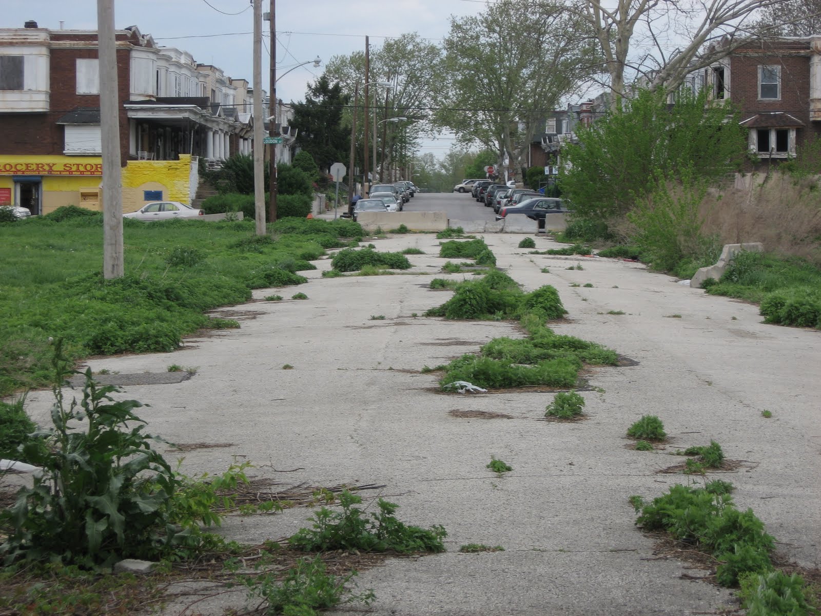
the park lays a huge swath of vacant land. It was like wandering into the City of Detroit. 


In the center of this apocalyptical field lays one sole house that seems to have evaded the fate of his counterparts. Naturally I went over the concrete barriers to explore. It was so creepy to be on a road that for the most part was just a strip of cracked asphalt, except for one odd 20 foot section that had a house, sidewalk, and 3 overgrown street trees. The house didn’t even look abandoned. Upon closer inspection of the site I noticed there were a few other abandoned streets that had houses on them, or half houses. 


While riding through this area I wondered what on earth happened. I know Philadelphia has lots of very beat up, abandoned neighborhoods but this area seemed different. The surrounding neighborhood was fairly vibrant and there are few areas in the city that look as systematically abandoned as this section. Turns out that the 35-acre area I biked through is known as the Logan Triangle, which I remember hearing about as some part of Penn Design’s studio list. It is a part of the city that was built up in 1920s as housing by filling in a 45’ stream bed.  Apparently filling in that much area leads to a lot of unsettling and over the next few decades several of the homes began to show signs of major structural and foundation damage. By the 1980s the City bought out many of the home owners, relocated them and demolished the houses. Since then the area has remained vacant with several attempts of redevelopment. In 2002 the Planning Commission released the Logan Area Redevelopment Plan which in so many words called for the area to become a shopping center. However due to the insurmountable environmental costs of refilling the area (ULI estimated the costs to be $50 million in 2009) and the fact that not all of the area is owned by the Redevelopment Authority, no project ever took off.  Currently ideas are being floated around to find some alternative use while waiting for demand for retail development to return; ideas such as a tree farm, community garden, etc. In late 2010, the National Park Service offered assistance in creating a new plan that would focus on redeveloping the area as a green/recreational space.  For now it is just a reminder that if you’re going to develop over centuries of Mother Nature’s work, make sure you do your due diligence. 

After my foray into bustedville I entered the neighborhood of Olney.  The neighborhood did not begin to develop until the early 20th century and rapidly urbanized with the introduction of the Broad Street line in 1928. During the 1960s, Olney had the largest high school in the city, one of the largest theaters and even its own symphony. As in many city neighborhoods the latter part of the century was characterized with deindustrialization and shifting demographic patterns. Olney is now one of the most diverse neighborhoods in the city; large parts of the west are predominately African –American and along 5th Street there are thriving Hispanic and Asian American shopping districts. Much of Olney’s housing stock was constructed later than the traditional Philadelphia rowhouse. There are elements of 20th century rowhouse architecture, predominately, porches, steeper rooflines, and front yards. Olney has very similar architecture as Southwest Philly and Frankford.   


Within Olney lays Fisher Park, a 23 acre park that is part active recreation and part wooded trails. The park was originally laid out by Joseph Wharton (of UPenn Wharton fame) and donated to the city as a “Christmas gift” in 1908, must be good to be rich. As with many of the parks in the city it is in desperate need of maintenance. However the wooded ravine is a nice oasis with several trails. Many of the trails have trail markers that I found unique. The signs posted a lot of random information about the short paths such as, average grade, the cross slope and the trail width. 


While riding up 5th Street I was unaware of crossing between Olney and East Oak Lane. 5th Street became wider and had more auto dominated businesses along it and I was really focused on biking up a hill that seemed to be never ending.  On the right of me there was a giant empty reservoir and I took the moment to stop, drink some water, and snap these pictures.


In the one looking down the hill you can see a tall building off in the distance, that’s the St. James at 8th and Walnut. That’s when I realized it’s going to be a long ride bike. Within a couple minutes I hit Cheltenham Ave and took another break, mostly to figure out how to bike along the really busy avenue.  I biked northwest until I went under a railroad bridge and realized that these cars were not going to be as cautious 
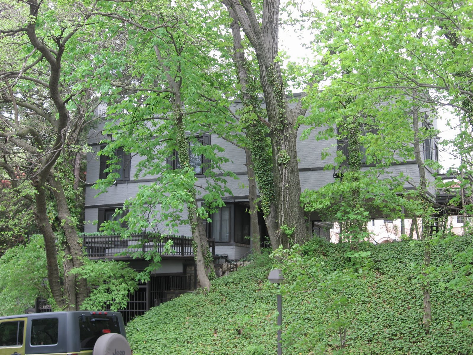
as in the city. I ducked into a street on the left to find this:


A suburban stretch of street that had houses that would rival the architectural grandeur of Mt. Airy or Overbrook.  The further I biked through these streets I found all different types of housing from Victorian and Tudor Revival to Modern houses. Additionally, all of these abodes were tucked graciously into huge, gorgeous white and purple bushes.

Apparently large single family houses and large lots are what define the neighborhood of East Oak Lane. Until I researched the neighborhood, according to their neighborhood association website the area is William Penn’s first neighborhood as part of his green country town. While I feel like that’s a bold claim, apparently the area was laid out and much of the land was claimed in the late 17th century. The green country town didn’t really develop until the late 19th century when it became a Victorian, wealthy summer resort. Kind of like The Hamptons of Philly.  Many of the large vacation estates were subdivided into smaller lots for single family houses in the early 20th century an in the 1950s many of the permanent residents (mostly white) fled across Cheltenham Ave to areas such as Elkins Park and Melrose Park. Now the area is predominately African-American and Asian-American. Regardless of its demographics or history East Oak Lane is absolutely spectacular. Along with the burst of spring colors when I biked through, the diversity of architectural styles is awe-inspiring. 

A nice Victorian house almost set up for a transition into a haunted house if needed


A beautiful (huge) Tudor Revival


The Modern collection


And of course my favorite, the Arts and Crafts bungalow


Lastly there was spring everywhere!


After a month in the making I finally made it all the way up 5th Street to the city’s border. Hope you enjoyed it and maybe now I can blog about some of the other interesting rides I’ve been on.  

Monday, May 16, 2011

Week 10 in Review (May 9 - 15)


Albeit that I haven’t updated my blog with interesting post about my ride at all really this week, I ended up biking around a lot.  I took a ride to Germantown, via a route through Brewerytown, Strawberry Mansion and Allegheny West.  It was really fascinating but by the time I reached Germantown I was pretty tired and people were not very nice. It’s also a rather grubby section of the city, although the main strip looked a tab cleaner than the last time I had seen it.  Additional to my Germantown ride I started to bike do laps around FDR Park in South Philly (My favorite park)


Routes
Miles
Minutes
Speed
Calories Burned
3
56.3
251
13.46
3,021

The FDR Park laps have started to satisfy a competitive side in me.  A lap is once around the drive that circles the ponds in the park, it’s roughly 1.65 miles.  The first day I did laps I did 4 of them and one lap I did in 5min and 18 sec. which is the fastest I’ve ever biked around there, it’s an average 18.7 mph.  Over all I averaged less than 17mph for all four laps.  However on the second day that I went (I also did 4 laps) I was much more consistent and was a little quicker overall with slightly higher than 17 mph, 17.2.   That was my adventure for the week. 

I made a large gain in the percentage of Philly I’ve been through. This week I have cycled through just shy of 17.12% of the entire city or 25.5 sq. mi.  Additionally I’ve made great gains in the number of neighborhoods I’ve been in, 97 out of 138 neighborhoods or 70%.

As always make sure you check out the Geographic Analysis page for a more in depth look.   


Tuesday, May 10, 2011

Cross Section of Philly, via 5th Street (Upper North Philly edition)


This 5th Street series is getting a little out of control. I never expected it to be 5 posts long. Thanks for allowing the geek out.  I suppose I need to sometimes. This post is getting into areas that I’m only familiar with by name mostly so they were total discoveries.  


As stated in the last post I biked through West Kensington, which is oddly north of Old Kensington, but has the same post-industrial landscape.  According to Wikipedia, West Kensington was the home to Rocky in the movie series so they have that going for them.  However since the 1970s/80s the area has had a dramatic demographic shift. Beginning in West Kensington and continuing into the neighborhood of Fairhill 5th Street becomes a vibrant commercial corridor that is the heart of the Philadelphia Hispanic community.  Over the past fifty years the two neighborhoods have predominately become home to Puertorriquenos, Dominicanos and Columbianos, so much so that the stretch of 5th Street between Lehigh and Allegheny is formally known as El Centro de Oro or the Golden Block.  The area is also home to community groups such as Asociación Puertorriqueños en Marcha  (APM), Congreso de Latinos Unidos, and the  Hispanic Association of Contractors and Enterprises (HACE) which are very active throughout the city’s Hispanic community. 

When traveling through El Centro de Oro I noticed a lot of construction activity, the neighborhood was completely redoing their streets. Naturally I was really excited to research what they were doing.  Apparently HACE, a Main Street organization, prepared design guidelines a few years back that called for the stretch of 5th Street to evoke the Caribbean culture of the neighborhood.  Last year they secured financing from the state and city for the $3.8 million project and began construction. 

While I could find no design drawings of the proposed streetscape the project seems like it is nearing completion.  While I was there they were painting the sidewalk with a wavy yellow strip to suggest a yellow brick road.  Along with the metal palm trees the plan calls for the street might turn into THE most post-modern streetscape the city has done.  And there is a lot of competition for that designation surrounding Independence Mall.  The plans additionally will dispose of the overhead wires along the street, add new planters and benches, improve signage, and create pedestrian bumpouts at intersections.  I think I might have to bike back up here in a few months to check out the progress.  I’m really intrigued by metal palm trees.


While the 5th Street was full of vitality, when biking back down 8th street through Faihill there were certainly signs of a extraordinarily high poverty rate.  Crime, poverty and drug activity plague the area. I was forced to bike down Franklin Street through Fairhill on my return and I ended up in a small intimate street that was very typical of Philadelphia blocks.  However this stretch of Franklin Street contained barred in porches; nerve-racking when people decide to imprison themselves.  As I biked down the street I had a beautiful abandoned building in the vista. 


I snapped that picture while on my bike and then a car slowed down and stopped right in front of me. I awkwardly had to pass them while they gave me a death stare. So instead of stopping and getting more (or even a better picture) I bolted. 

The abandoned building is the old Thomas A. Edison High School/Northeast Manual Training Center. Originally built in the early 20th century and it was expanded for a vocational school in the 1930s.  In the late 1950s, the Northeast Manual Training Center became Northeast HS, famous for Tony Danza’s foray into teaching. The building remained Edison HS, however with much less funding and more diversity. In the 1980s a new building was created for Edison/Fareira to the east and the original building was partially used as various other schools until completely abandoned in the late 1990s. 

There are several articles/posting about the building including this amazing video and a four-part blog photo series: part 1, part 2, part 3, part 4. 

Just north of Fairhill is Upper Kensington (yes another one) and Hunting Park.  These neighborhoods are physically separated by the large Northeast Rail Corridor.  This corridor runs through North Philly and contains Amtrak’s Northeast Regional and Acela trains, NJ Transit’s trains to Atlantic City, and SEPTA’s Trenton Line trains.  Needless to say it’s a very busy stretch of transit infrastructure, and as anything dealing with trains it once was a lot busier.  Much of the land along the two streets paralleling the corridor, Sedgley and Glenwood, is home to large vacant industrial buildings or land providing an additional barrier between neighborhoods.  And planners are always complaining about highways and interstates cutting through cities, rail also has serious implications on urban form.

This building at 5th and Glenwood I thought was a one of the more interesting buildings I saw along the corridor, although it’s partially abandoned. 


Looking back down 5th Street one can tell how much of an ascent there is to bridge over the corridor (many of the crossings are under the rail lines)


When traveling back to the Center City I crossed over a mini rail corridor along Sedgley Ave. on a bridge that looks as if it would fail the DOT standards for safe bridges.  Turns out it was constructed in 1906.


This bridge however provided some awesome vistas of the industrial landscape surrounding this area. 


Anyway, the neighborhood of Hunting Park is so named because of the large park that resides in the area.  The 87 acre, Hunting Park, has a sorted history. The area dates as far back as the 18th century, when William Penn’s secretary, James Logan (of Logan Circle fame) decided to build his country estate here. His house still stands at the southwest corner of the park but is boarded up. In the early 19th century the park was home to a horse racing track but that was scrapped when horse racing became illegal in the 1850s. The park has since been used as a passive/active recreational space. A little fact that I learned while researching, the park once had a carousel until 1967, when it was moved to Cedar Point, in Ohio.  I’ve ridden that carousel!


Until next time, please feel free to check out the other parts of this series:

Monday, May 9, 2011

Cross Section of Philly, via 5th Street (Lower North Philly edition)


In continuation of my 5th Street ride series this post is all about Lower North Philadelphia or, as known by many, “the area you don’t go” 


After emerging from the tunnel, bypassing much of Old City and more importantly tons of automobile dominated infrastructure, I found myself in Callowhill


Callowhill is an area, in short, that was built up as an industrial district in the late 19th century and continued to thrive as such until the mid 20th century.  It is now a collection of old industrial buildings (some vacant, some are cool loft apt/condos), mid-century office buildings and parking lots. Lots of parking lots.  There are several plans for the area, to redevelop some of the buildings for medium/high density loft style housing, reconnect the area to Chinatown and there is even talk of turning the abandoned Reading Terminal viaduct into a High Line-esk park.  Also, the area does have some spectacular views of the city’s skyline. 


The Callowhill district is not very wide and after about 5 blocks, I crossed over Spring Garden and entered Northern Liberties.  Northern Liberties is one of the oldest neighborhoods in the city. As mentioned in a previous blog post the neighborhood is home to the site when William Penn struck a treaty with Native Americans.  Much like the Callowhill district the area was home to several industrial complexes, mainly breweries such as Schmidt’s and Ortlieb’s, along with a large number of residences for industrial workers.  After many of the factories downsized and eventually shuttered the neighborhood went into disrepair and began a renaissance in the 1980s as an artist/bohemian community. As seen in many cities across the U.S. this low-rent, artistic community became a catalyst for new development in the area and the neighborhood is now better known for interesting architecture, innovative planning projects (i.e. Liberties Walk and the Piazza at Schmidt’s) and hipsters. Even the hipsters are beginning to be priced out. The neighborhood’s main commercial corridor is along 2nd street, but shops/restaurants and cafes can be found on the corners of many of the numbered streets.  After all that I don’t have many interesting shots of the neighborhood; I guess I’ll have to go back. 


The edge of Northern Liberties is Girard Avenue, a very wide, commercial corridor.  In 2005, SEPTA reinstated the trolley line that ran along Girard Avenue using historic 1947 PCC trolleys.  While planners typically advocate for fixed rail transit to help revitalize corridors, I’m not sure what the Girard trolley has done for the neighborhoods along it in the past 5 years. It seems more like a historical Disney ride than a functional transit line. The design of the stops and layout of the street does nothing to promote pedestrian safety and comfort along the 7 lane road.  The stops are not covered, and are essentially concrete steps in between moving traffic lanes. Additionally, the trolley runs only every 15 minutes during peak times and is not timed with either subway that it crosses, making it function more like a bus than anything else.  Sorry, that’s enough railing against Philadelphia transit for now, like much of SEPTA…they’re getting there. 


One the other side of Girard is the beginning of Old Kensington. To be fair there are a lot of different Kensingtons throughout Philadelphia’s Lower North/Northeast sections: Old Kensington, West Kensington, Upper Kensington, New Kensington…..  From what I can tell they are all fairly the same; historically industrial neighborhoods with vacant industrial lots, very underserved retail corridors and modest rowhouses.  I biked through two of the Kensingtons this ride: Old and West. 

Old Kensington is the industrial heart of the city; many of the factories located here were well known while Philadelphia was ticketed as the Workshop of the World.  I cycled past two relatively large industrial buildings that pretty much sum up the entire area, the vacant Drueding Brothers Leather Co. and the recently converted Sewing Factory Lofts. 

The Drueding Bro. was part of the area’s leather and tannery history and through what I can find closed in the 1960s, lying vacant ever since.  The buildings windows are completely broken out, the roof line looks so rusted that it is beginning to disintegrate, and some daring hoodlum (probably hipster) has sprayed the words Tape Radio across the middle floors of the building.  While researching this building I found this link that contains several photos inside the building and along the roof.  Pretty impressive. 


On the other hand, the Sewing Factory Lofts building is one of the courageous residential developments venturing far north of Northern Liberties.  The building contains 52 loft style apartments ranging from 1,400 to 2,200 square feet renting for $1,100 -$1,800.  While only slightly less expensive then comparable buildings nearer Center City, the building has lofts that are typically twice the size. I guess if you want a very large loft space, Kensington is the place for you. 


I suppose the price drop is because this is the scene right outside the building.


Many of the vacant lots across the neighborhood have either become defacto wildlife refuses or “temporary” homes of the homeless. Just to the west of this area is Ludlow and Temple’s main campus.  On my way back to the city I biked down 8th street which afforded me and amazing view of Septa’s regional rail station. 


The station is set up on the train line and the view is possible due to the fact that there is a large vacant lot on the east.  The City, Temple and other various organizations have been trying to lure a developer here for a while. The area has been designated as a TRID or Transit Revitalization Improvement District, a state designation that allows municipalities and transit agencies to work together and apply for state funds to plan and study the area.  More importantly a TRID allows for the creation of an organization that can capture additional tax revenue and pay for capital improvement in the area, similar to a BID or business Improvement District.   The Asociacíon Puertorriqueños en Marcha (APM) is leading the development of the lot for the past few years.  However despite the TRID, and having federal funds in place the team is still attempting to find financing for a 164 mixed-income apartment and retail development.

For more information please follow the links here, http://planphilly.com/nutter-breaks-ground-parkway-temple-projects and http://planphilly.com/node/3631.  I know that I didn’t get all that information. 

Nearby the train station I was totally caught off guard to see a row of houses that seem to be fairly well kept sitting in the middle of a green and deliberately planted block, so naturally I decided to explore.  Biking down Darien Street I discovered this horse and immediately thought it was some urban farm project.


However, the landscaping was too passive to be farming. Then I discovered a sign along the NTI looking fence.  It turns out that it’s some sort of pilot project for the Philadelphia Water Department and or the EPA.  I’m a little over researched right now form looking up the TRID development, but the while idea seems to be a really cool.  There are rolling swales and planted lawn/trees to minimize stormwater runoff.


That's about all I can blog about for now.  Stay tuned, I'm only HALF way up 5th Street.